Traffic accidents are a major cause of fatalities worldwide. It is estimated that more than 1 million people are killed and 50 million are injured in the world every year as a result of road crashes. These accidents bear heavy economic burden, including hospitalization expenses and loss due to property damages. Recently, it was estimated that the economic burden of traffic accidents amounts, on average, to 2% of the world GDP.
Automotive manufacturers, companies in the private market and academic institutes keep investing many resources into research and development of Advanced Driver Assistance Systems (ADAS). These systems are primarily aimed at saving the lives of both drivers and pedestrians by warning the driver before critical situations or – when crashes are inevitable – by preparing the car to minimize their consequences. ADAS solutions combine several sensory inputs coming from sensors mounted on the car and process them in real-time. Among the most frequent sensory input, one finds LIDAR (Light detection and ranging) and cameras.
Automotive manufacturers, companies in the private market and academic institutes keep investing many resources into research and development of Advanced Driver Assistance Systems (ADAS). These systems are primarily aimed at saving the lives of both drivers and pedestrians by warning the driver before critical situations or – when crashes are inevitable – by preparing the car to minimize their consequences. ADAS solutions combine several sensory inputs coming from sensors mounted on the car and process them in real-time. Among the most frequent sensory input, one finds LIDAR (Light detection and ranging) and cameras.
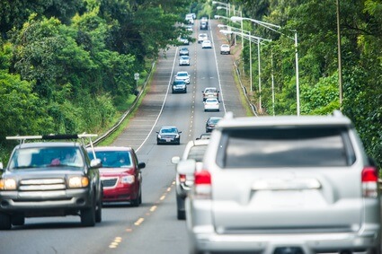
The richness of visual sensory information has motivated the implementation of vision-based ADAS algorithms. Vision-based systems can be found operating with the task of preventing lane departure, detecting traffic signs and adapting the car to the type of road being driven on.
Vision-based detection and localization are challenging tasks in the highly dynamic driving environment. Owing to the large variability of car shapes and the environmental conditions (e.g. visibility and weather), algorithms constructed for vehicle localization must operate fast, filtering out non-relevant objects and diverting processing time only to the relevant ones.
For the most part, cars are restricted to driving in lanes and any deviation from them should ignite a warning signal. Therefore, the most attractive scientific approach suggests to initially detect lanes, the geometrical complexity of which is several orders of magnitude lower than cars; and after that to detect objects within them. However, this task carries with itself several challenges, primarily due to partial occlusion by nearby cars and obstacles, noise and poor illumination. Difficulties can be circumvented by using a top bottom approach where a lane model is fitted to the visual information collected about the road (based on edges or features extraction). Statistical approaches (like RANSAC – RANdom SAmple Consensus), coupled with imposing continuity of the road, can make the model detection robust.
Detection and tracking of the lane can then be used to restrict the region of interest in which cars are detected and tracked. Detection of cars is carried using a trained classifier, distinguishing cars from non-cars object (e.g. their shadows). The temporal information gathered from several successive frames of successful car detections can be used to the purpose of 3D positioning of the detected vehicle.
The use of temporal information in the tracking procedure is critical for higher level processing such as drivers’ intention prediction. The relative speed and position of the detected car put in the right contextual information (urban vs rural driving, time of day, number of lanes, density of cars, etc.) is processed by vehicle localization algorithms employing motion prediction. One such common choice is the use of Kalman filter to predict the trajectory of detected cars based on the information gathered on it so far.
The decision taken by the ADAS system in light of the information passed to it can save lives. It is therefore imperative to construct algorithms maintaining the highest quality of vehicle detection and tracking. RSIP Vision and its engineers follow the highest quality standards: our high-end custom-made software systems have been successfully integrated into many modules and solutions around the world. Read more to learn how RSIP Vision can help you with the stringent performance requirements of ADAS.

